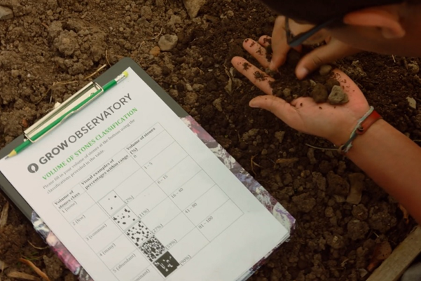
 Once you have defined which parameters you want to monitor, the next step is to prepare the actual data collection tools. This stage is essential to provide a structured way to collect robust data. Depending on who does the measuring and observing, these tools may vary. Tools can include manuals and guides for sensing (using sensors for data collection), as well as data recording sheets and journals. Tools for data recording can come in digital and non-digital forms, for example as smartphone apps, printable data recording sheets, or online forms.
Think about the pros and cons of digital versus non-digital recording. Can you think of when you last recorded any data yourself? How did you do it
Once you have decided on the information that you need to capture, you'll need to decide how to train the citizen scientists you are working with, so that they can go ahead with data acquisition.
You may need to set a new platform for users to create new projects, modify existing ones, and view project data on a map that shows the locations of where observations were made, as well as observation data. Scent Campaign Manager is an example. It allows policymakers and authorities to design citizen science campaigns. Users can define specific areas where data on land cover and land use, soil conditions and river parameters are needed.

If you work on a citizen science project with other people to measure and record data, sensing guidelines and manuals can support participants to provide regular, high-quality data. They usually include, at a minimum, the following:
A manual can help participants follow an observational routine or a step-by-step process. Having manuals and guidelines makes it more likely that people will stick to agreed protocols because these resources will show them where to measure and what to pay attention to.
Guidelines can also help people make sense of the data they have recorded and put them in a larger context. If the community defines which parameters to measure, they should also draft the manual together. Doing this will make everyone aware of how important it is to have a structured approach. To see an example of a sensing manual, take a look at the GROW Changing Climate Mission Manual.
Sensing guides provide a structured process that you can follow. Data sheets and recording tools are where you record the actual observations and measurements. Data journals are extended versions of data sheets, where additional observations can be captured.
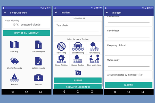
Here is a visual example of the FloodCitiSense smartphone app; Citizens can use this tool to record the details of a flooding incident to support an early warning system for urban pluvial floods.

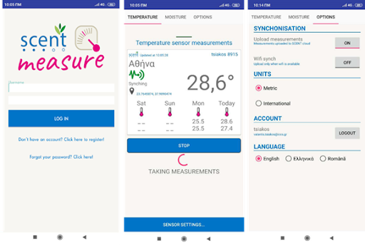
Another example can be found in the SCENT Measure application. Using portable sensors, this app measures and records the soil moisture and air temperature to the user’s smartphone or tablet.

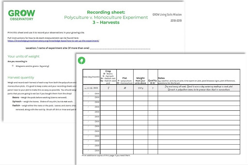
This is an example of the collection sheet and data journal for crop yield data for an experiment from the GROW Observatory. The data are first recorded on a data sheet and then submitted digitally using an online form.

Which data recording and sensing tools are best for your project will largely depend on:
Some free open-source technologies are available for creating custom-made data collection tools, such as OpenMapKit, GeoODK or EpiCollect5. You can also use other free of charge online services such as Google Forms and Sheets.
The Austrian Center for Citizen Science provides an overview of helpful tools to set up data recording citizen science projects.
WeObserve has a Toolkit with a selection of tools across four different categories:
Evaluation and advocacy
Select a tool. What do you think its advantages and disadvantages are?
In this video, you heard Professor Mel Woods explaining how the WeObserve Citizen Observatories have trained people to collect data. For all of the Observatories, learning to collect data has been a social experience, with collaboration at the core.
We discussed some of the projects that are coming out of Ground Truth 2.0 and the GROW Observatory. In the video, Mel mentioned the different ways people trained for data collection in the projects:
You can also find more information on training for data collection using these resources:
VattenFokus is a citizen observatory made up of volunteer citizens, politicians, researchers, municipal employees, and others. Together, they test and collect data on our lakes and streams to monitor the health of our waters.
VattenFokus is part of Ground Truth 2.0, a three-year EU-funded project that tested the setting up of six national observatories under real-world conditions in different parts of the world. Citizens' own observations, with the help of modern technology, the Internet and mobile telephony will complement existing systems and data sources and lead to a better environment.
Image 1: GROW Observatory (CC)
Image 2: SCENT project (CC)
Image 3: IIASA (CC)
Image 4: SCENT project (CC)
Image 5: GROW Observatory (CC)